Skip to main content Skip to search Skip to main navigation

The Sea Chart N 473 covers the approaches to Porsgrunn and the Grenlandsområdet. The sea area off Langesund Stathelle Brevik Frier Asdaltangen to Herøya are shown in detail at a scale of 1:20000. This nautical chart is printed on customer request from the publishers current data using the print-on-demand (POD) process.

The 2020 edition takes into account the new surveys and depths in this area.

POD charts are excluded from exchange.

For more information on official Norwegian nautical charts printed by HanseNautic using the print-on-demand (POD) process please click here.

Sample detail for nautical chart N473

Detail of Langesund - Herøya - Norway Chart 473

Manufacturer "Kartverket (NOR)"

Kartverket (NOR): Nationale Seekartenbehörde Norwegens und Herausgeber der amtliche, norwegischen Seekarten

Kartverket ist die offizielle Kartografie- und Katasterbehörde, die für Vermessung, Geodäsie, Hydrografie, Kataster und Kartografie Norwegens zuständig ist und bietet eine breite Palette an Seekarten und Navigationslösungen für den maritimen Bereich.

Bereits 1773 wurde ein Vorläufer der Institution gegründet, der norwegische geografische Dienst. Den Bereich Kartverket in seiner heutigen Form gibt es seit 1986, als die zuvor eigenständige Behörde Norges Sjøkartverk mit der Katasterbehörde zusammengeschlossen wurde.

Die Produkte von Kartverket decken alle norwegischen Gewässer ab und enthalten präzise und zuverlässige Informationen für die sichere Navigation. Mit jahrzehntelanger Erfahrung und modernster Technologie stellt Kartverket sicher, dass sowohl professionelle als auch private Bootsfahrer exakte und aktuelle Karten für ihre Reisen nutzen können. Die Karten sind sowohl in gedruckter Form als auch digital erhältlich.

Handhabung und Erscheinungsbild

Die Karten sind auf speziellem, gegen Nässe beständigen Papier im A0-Format gedruckt. Sie kommen einmal gefaltet, um einen sicheren Versand zu gewährleisten.

Übersichtlichkeit und Inhalt

Das Kartenbild ist sehr detailliert gezeichnet. Durchfahrtskarten bei Engstellen, Detailkarten und Hafenpläne mit größerem Maßstab sind in der Regel nicht enthalten. Alle offiziellen norwegischen Karten sind mehrfarbig. Land in Gelb, Tiefenlinien in Blau gedruckt. Flachwasserbereiche sind in Hellblau dargestellt. Licht-Sektoren für die Navigation bei Nacht sind in drei Farben gedruckt. Gefahren- und Ausschlusszonen sowie Naturreservate werden vollständig dargestellt. Auch Gebäude, Höhenlinien und Landstrukturen werden zusammen mit Waldflächen und Straßen gedruckt.

HanseNautic Service

HanseNautic druckt die offiziellen norwegischen Seekarten auf Kundennachfrage. Normalerweise können wir am selben Tag versenden, an dem die Bestellung eingeht. Alle Produkte sind verfügbar.

Korrekturen

Die Druckdatenbank wird alle zwei Wochen vom norwegischen hydrographischen Amt aktualisiert. Wir bei HanseNautic drucken stets aktuelle Karten für unsere Kunden. Eine Korrektur der Karten nach Auslieferung ist möglich. Die News für Seefahrer (EfS) werden online veröffentlicht: www.kartverket.no/en/EFS/#/

Direkt zur Kartenauswahl bei HanseNautic:

0 of 0 reviews

Average rating of 0 out of 5 stars

Leave a review!

Share your experiences with other customers.


Area preview

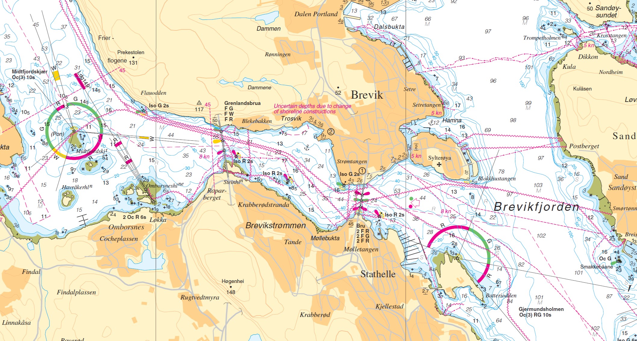
With the help of our area preview, you can get an impression of which geographical region the product deals with or which areas a nautical chart covers.

Related products to this item

Gebietsvorschau für FINN. BOOTSPORTKARTEN E öffnen
FINN. BOOTSPORTKARTEN E
The Finnish boating chart set E Selkämeri/Bottenhavet covers the south-eastern side of the Gulf of Bothnia. Within this set the coastal area is covered up to approx. 5sm distance from the coast. The m

€58.00*
Gebietsvorschau für NV Charts Norway NO2 - Oslofjord Sør, Svenska Grensen til Kragerø öffnen
NV Charts Norway NO2 - Oslofjord Sør, Svenska Grensen til Kragerø
The NV Charts Atlas NO2 covers the southern Oslofjord. NV Charts for the Norwegian coast are based on data from the Norwegian Hydrographic Office and also include the harbour plans of the "Norske Los"

€74.99*
Gebietsvorschau für Norwegen N 5 Oslofjord Svenner - Porsgrunn - Jomfruland öffnen
Norwegen N 5 Oslofjord Svenner - Porsgrunn - Jomfruland
The Sea Chart N 5 covers the western coast of the Oslofjord from the Svenner lighthouse to Jomfruland. The detailed scale is 1:50000. We print the chart on customer request from current data sets

€27.70*
Gebietsvorschau für Norway (RCC) öffnen
Norway (RCC)
A comprehensive cruising guide to the entire Norwegian coastal area from Oslo to Nordkapp and Svalbard.This RCC cruising guide covers the long and complex coastline of Norway from the Swedish border i

€85.00*

Similar products

NV Charts Nederland NL2 - Waddenzee

Variants from €58.49*
€59.90*
Gebietsvorschau für NV Charts Florida 8.4 - South Florida, Plantation Key to Key West öffnen
NV Charts Florida 8.4 - South Florida, Plantation Key to Key West
Plantation Key to Key West. 4 oversailers 19 coastal and 3 detailed maps with "Harbour & Anchorage Pilot". Format 30x42cm paperback. In English language. The set includes a download code for all m

€49.00*
Gebietsvorschau für Swedish Series Bottenhavet S Södra öffnen
Swedish Series Bottenhavet S Södra
The Swedish recreational boating chart set Bottenhavet S Södra is the southernmost of the three Swedish chart sets for the Gulf of Bothnia and the direct link to the Stockolm Norra chart set. This map

€78.00*
Gebietsvorschau für NV Charts Baltic Region 4 - East Germany Rügen to Szczecin, Single-Charts öffnen
NV Charts Baltic Region 4 - East Germany Rügen to Szczecin, Single-Charts
The NV Charts Baltic Series 4 Plano for the sea area Round Rügen - Bodden Waters - Szczecin is a chart series specially designed for recreational boating. It contains the nautical charts in various si

Variants from €59.99*
€74.99*
Gebietsvorschau für NV Pilot 1, planning chart Baltic Sea - Kristiansand to Helsinki öffnen
-0%
NV Pilot 1, planning chart Baltic Sea - Kristiansand to Helsinki
Planning chart for the Baltic Sea for sailorsThe Pilot 1 from NV Charts is an indispensable planning chart if you want to prepare for a Baltic Sea cruise. This chart for this popular sailing area exte

€24.99*