C-MAP Reveal Mittelmeer Gibraltar-Korfu, Azoren u. Kanaren (South-West European Coasts) EM-Y076
Description
Electronic chart for the southern European fishing and watersports areas in the Mediterranean for the modern chartplotters and multifunction displays from Simrad B&G and Lowrance.
Coverage
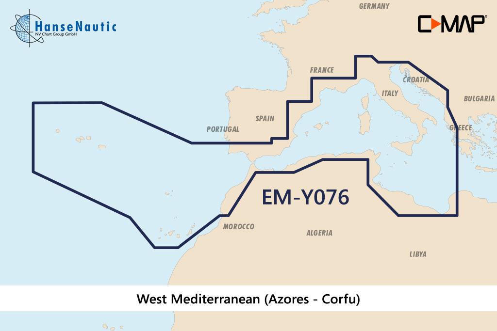
The C-MAP Reveal Mediterranean Gibraltar-Corfu Azores u. Canary Islands (South-West European Coasts) EM-Y076 offers a wide coverage for the holiday and fishing areas in Southern Europe
The following sea areas are included in this electronic chart:
- Mediterranean coasts of Spain (Andalusia to Catalonia) incl. Mallorca Ibiza and Menorca
- French coast with Gulf of Lyon Côte dAzur and Corsica
- Italy with Sardinia Sicily and all other island groups in the Mediterranean Sea
- Adria from Venice to Corfu with Croatian sea areas of Istria and Dalmatia
- Ionian Sea with Corfu and Westl. Peleponnes
- Malta Tunisia
- Coast of North Africa from Algeria Morocco
This coverage includes all areas popular with water sports enthusiasts in southern Europe and allows long and extensive trips through the Mediterranean to the Balearic Islands or holiday destinations on Sardinia the Côte dAzur or around Corsica with one map. Smaller fishing boats can be flexibly deployed to different fishing spots in the Mediterranean as well as from ports with this wide coverage.
Features of the new C-MAP Reveal nautical charts
C-MAP offers with the Reveal products high-quality nautical charts with additional benefits for anglers fishermen and demanding navigators. C-MAP Reveal are premium charts with extra display options of nautical and underwater information!
- Electronic Marine Charts - Vector charts with all nautical information continuous zooming from harbour plan to overview chart
- Easy Routing gives route suggestions based on the nautical chart data and your custom vessel information.
- Tide information includes high and low tide times and current data. A tide calendar and a current atlas are integrated into the chart
- RShadow relief representation of the seabed - Three-dimensional image of the seabed and shore slopes in highest resolution
- ROfficial raster sea charts - Especially for narrow fairways this representation offers known from paper nautical charts provides a better overview of the navigational situation.
- R Satellite images & aerial photographs provide information on the surroundings of an anchorage or harbour.
R Exclusive to C-MAP Reveal!
Disc
This EM-Y076 electronic nautical chart is supplied on an mSD disc which is contained in an SD card adapter.
Compatibility
The C-MAP Reveal Southern European Coasts is compatible with modern chartplotters from Simrad B&G and Lowrance.
Tip: Always state the make and model of your plotter when ordering your nautical chart to avoid incorrect deliveries. You can also check the HanseNautic compatibility list to see whether your chart plotter can process the C-MAP Reveal charts.
Revocation excluded
These nautical charts are produced by us for you on customer request in order to always provide you with the most up-to-date data. For this reason, the charts are excluded from exchange and revocation.
| Format: | mSD-Karte |
|---|---|
| Size: | Wide |
With the help of our area preview, you can get an impression of which geographical region the product deals with or which areas a nautical chart covers.
Products near this article
Reviews
Login


