Skip to main content Skip to search Skip to main navigation

Official Sailing Manual English ADMIRALTY Sailing Directions Irish Coast Pilot

The Irish Coast. Contains the route to the Irish Coast.

NP40 is part of the world series of books published by the United Kingdom Hydrographic Office (UKHO). They comply with the SOLAS equipment regulations for commercial shipping. In English with numerous photographs maps sketches and illustrations. 2019 21st edition.

Contents

The ADMIRALTY Sailing Direction Irish Coast Pilot (NP40) provide the following topics in detail for the Pacific Islands area:

  • Navigation Routes Routes and Traffic Management Areas (TSS)
  • Port Facilities Quay facilities and berthing information
  • Instructions for port entrances
  • Nautical hazard information
  • Betonning and approaches
  • Climatic background information

Geographical coverage

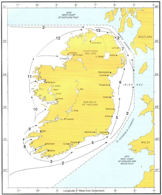
The maritime area is divided into thirteen sections along the coasts. (See graphic). It includes

  1. Countries Navigation and Regulation
  2. Transit routes from the Atlantic Ocean to the Irish Sea
  3. Harbours off south-west Ireland - coastal waters from Bantry Bay to Cork Harbour
  4. South coast of Ireland - Cork Harbour to Saint Georges Channel
  5. East coast of Ireland -. Saint Georges Channel to Dublin Bay
  6. East Coast of Ireland - Dublin Bay to Strangford Lough
  7. East Coast of Ireland - Strangford Lough to Fair Head
  8. South West Coast of Ireland - Dursey Head to Sybil Point
  9. South West Coast of Ireland - Sybil Point to Loop Head including River Shannon
  10. West Coast of Ireland - Loop Head to Slyne Head including Galway Bay
  11. West Coast of Ireland - Slyne Head to Benwee Head
  12. North West Coast of Ireland - Benwee Head to Fanad Head. Benwee Head to Fanad Head
  13. North Coast of Ireland - Fanad Head to Fair Head

Cover NP40 Irish Coast

ADMIRALTY Sailing Directions for SOLAS equipment-required shipping

UK Sailing Directions are part of the bridge equipment required on board merchant ships under SOLAS. Depending on the rules of the flag state the necessary official publications and sea manuals must also be on board in addition to the current nautical charts.

ADMIRALTY Sailing Directions are also a useful piece of equipment for navigation on board in non-equipped recreational shipping. Especially in areas where coverage with cruising guides is not possible or not in up-to-date form many skippers resort to the sea manuals.

Numerous illustrations colour photos and sketches facilitate navigation.

Updating the ADMIRALTY Sailing Directions

For the United Kingdom Hydrographic Offices sea manuals the publishers provide free weekly updates on the homepage. These are published as part of the Notice to Mariners. You can also order a subscription for a weekly delivery of the paper version of the Notice to Mariners from your chart suppliers HanseNautic. Feel free to contact us.

https://www.admiralty.co.uk/publications/publications-and-reference-guides/admiralty-sailing-directions

0 of 0 reviews

Average rating of 0 out of 5 stars

Leave a review!

Share your experiences with other customers.


Area preview

With the help of our area preview, you can get an impression of which geographical region the product deals with or which areas a nautical chart covers.


Similar products

Gebietsvorschau für ADMIRALTY NP52 North Coast of Scotland Pilot - Seehandbuch öffnen
ADMIRALTY NP52 North Coast of Scotland Pilot - Seehandbuch
Admiralty Sailing Directions. North Coast of Scotland Pilot. North and North-east Coasts of Scotland from Cape Wrath to Rattray Head including the Caledonian Canal Orkney Islands Shetland Islands and

€112.90*
Gebietsvorschau für ADMIRALTY NP62 Pacific Islands Pilot Vol 3 - Seehandbuch öffnen
ADMIRALTY NP62 Pacific Islands Pilot Vol 3 - Seehandbuch
Official Sailing Manual English ADMIRALTY Sailing Directions Pacific IslandsThe Islands in the Central Part of the Pacific Ocean. Includes Isla Sala y Gómez the Austral Islands (French. Îles Australes

€112.90*
Gebietsvorschau für ADMIRALTY NP46 Mediterranean Pilot Vol 2 - Seehandbuch öffnen
ADMIRALTY NP46 Mediterranean Pilot Vol 2 - Seehandbuch
Admiralty Sailing Directions. Mediterranean Pilot Vol. 2The south coast of France from Cap Cerbère to the Franco-Italian Frontier the islands of Corse and Sardegna the west coast of Italy from the Fra

€112.90*
Gebietsvorschau für ADMIRALTY NP54 North Sea (West) Pilot - Seehandbuch öffnen
ADMIRALTY NP54 North Sea (West) Pilot - Seehandbuch
Admiralty Sailing Directions North Sea (West) Pilot 10. Edition 2016. East coasts of Scotland and England from Rattray Head to Southwold.

€112.90*
Gebietsvorschau für ADMIRALTY NP56 Norway Pilot Vol 1  öffnen
ADMIRALTY NP56 Norway Pilot Vol 1
Official ADMIRALTY Sailing Directions for Norway (South Coast)The Skagerrak and the coast of Norway from Egersund/Jaerens Rev to the Norwegian/Swedish border and on to Marstand are covered in detail.

€112.90*
Gebietsvorschau für ADMIRALTY NP28 Dover Strait Pilot - Seehandbuch öffnen
ADMIRALTY NP28 Dover Strait Pilot - Seehandbuch
Admiralty Sailing Directions. Dover Strait Pilot 12. Edition 2017. South-east coast of England from Bognor Regis to Southwold North-west coast of Europe from Cap dAntifer to Scheveningen.

€112.90*
Gebietsvorschau für ADMIRALTY NP20 Baltic Pilot Vol 3 - Seehandbuch öffnen
ADMIRALTY NP20 Baltic Pilot Vol 3 - Seehandbuch
Official Sailing Handbook engl. ADMIRALTY Sailing Directions Baltic SeaGulf of Finland Bothnian Gulf and AlandNP20 is part of the world series of books published by the United Kingdom Hydrographic Off

€112.90*
Gebietsvorschau für ADMIRALTY NP15 Australia Pilot Vol 3 - Seehandbuch öffnen
ADMIRALTY NP15 Australia Pilot Vol 3 - Seehandbuch
Admiralty Sailing Directions. Australia Pilot Vol. 3East Coast of Australia from North Head to Cap York Great Barrier Reef islands and reefs of Coral Sea Great North East Channel Torres Strait. South

€112.90*
Gebietsvorschau für ADMIRALTY NP1 - Africa Pilot Vol. 1 - Seehandbuch öffnen
ADMIRALTY NP1 - Africa Pilot Vol. 1 - Seehandbuch
Admiralty Sailing Directions Africa Pilot Vol. 118th Edition 2017.Arquipelago da Madeira Islas Canarias Arquipelago de Cabo Verde West coast of Africa from Cap Spartel to Presquile Bakasi (Bakassi Pen

€112.90*
Gebietsvorschau für ADMIRALTY NP27 Channel Pilot - Seehandbuch öffnen
ADMIRALTY NP27 Channel Pilot - Seehandbuch
Official ADMIRALTY Sailing Directions for the English ChannelThe coastal sections of the English Channel from Great Britain (Isles of Scilly and South Coast of England from Cape Cornwall to Bognor Reg

€112.90*
Gebietsvorschau für ADMIRALTY NP67 West Coasts of Spain and Portugal Pilot - Seehandbuch öffnen
ADMIRALTY NP67 West Coasts of Spain and Portugal Pilot - Seehandbuch
Admiralty Sailing Directions. West Coasts of Spain and Portugal PilotFrom Cabo Ortegal to Gibraltar Strait of Gibraltar north coasts of Africa from Cap Spartel to Ceuta and Arquipelago dos Acores. Win

€112.90*
Gebietsvorschau für ADMIRALTY NP66B North-West Coast of Scotland Pilot - Seehandbuch öffnen
ADMIRALTY NP66B North-West Coast of Scotland Pilot - Seehandbuch
Admiralty Sailing Directions. North West Coast of Scotland PilotNorth West Coast of Scotland from Point of Ardnamurchan to Cape Wrath includingthe Hebrides and offlying islands.

€112.90*