
Function overview NV Charts App - More than navigation
The NV Charts App is published by NV Verlag, Germany's largest nautical chart publisher. It is the digital counterpart to the paper nautical charts and enriched with many useful functions around navigation, safety, voyage planning, exchange with others and time on the water. The app can be used on your mobile phone, tablet, iPad or PC and Mac.


Function overview
Note the system requirements of the app: https://eu.nvcharts.com/support/?faqdetail=31 .
Functions for navigation
- Boot and App - the ship's own data is taken into account in the navigation after it has been entered in the App
- Europe-wide autorouting jetty to jetty
- Flexible autorouting: manually edit segments
- Position with GPS
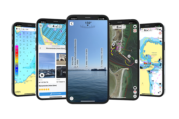
- Augmented Reality (AR): Data such as harbours, anchorages, navigation warnings or POIs and AIS signals from the surroundings are projected directly into the camera image in real time via the camera of the mobile terminal.
- Course recordings, markers, bearing ruler
- "On position function" for raster and vector charts (depending on the area): You can mark any position, beacon or buoy on the map by holding down and get information about that location
- Display of instruments such as NMEA, wind or echo sounder (depending on available instruments and on-board networking)
- Tide forecast with calculation and display
- Weather overlay as real time forecast of wind and currents, requires mobile data or WiFi
- Satellite overlay
- Change of view mode between raster maps, vector maps (available depending on area), satellite overlay or augmented reality view
- Customisation of the colour world (tracks in individual colour)
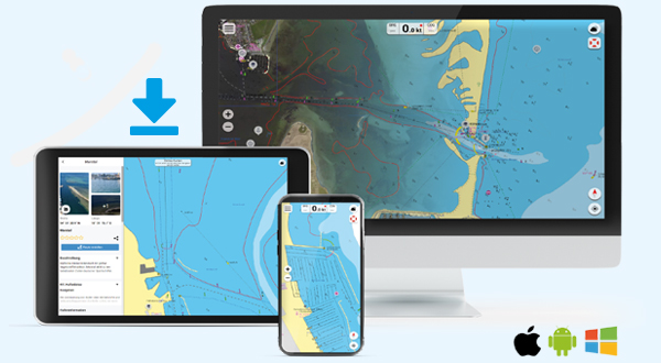
The app can be used on cell phone, tablet, iPad, PC or Mac. A maximum of 5 devices are possible at the same time.
Maritime safety functions
- Anchor alarm, also in standby mode
- MOB function (no AIS required)
- AIS Wifi support
- AIS Sart Beacon, if AIS available
- AIS CPA and TCPA function for collision avoidance
- Day-Night mode for optimised display on the terminal device
- Navigation instructions and warnings along the route
- Highlighted beacon display - in addition to the information on the beacon, the sectors are also displayed
- Overzoom display hint
- Synchronisation of devices: When using the app on different devices you are always up to date (prerequisite mobile data/ WiFi)
Functions for sporty sailing/ regatta
- Velocity Made Good mode (VMG) calculates the speed to reach the next waypoint downwind along the planned route - details on VMG mode
- Easy, quick setting of markers and custom points for planning a regatta route
- Weather overlay as real-time forecast for wind and currents
All functions can be used immediately as soon as a current digital nautical chart is stored in the app.
Handling and service functions
- Optimised search function for navigation instructions, ports etc.
- Data saving mode - limits synchronisation and saves mobile data
- Sheet section-free chart display
- Feedback function and error message for NV Charts customer service
- Offline mode for digital app maps
- Simple chart update management in the app
- New purchase of digital nautical charts directly in the app
- All NV nautical chart areas are also available digitally
- Vector and raster charts are available, depending on the area both views with full app functionality
- Plan free of charge in the preview and decide which nautical chart you need
- File exports are possible
- Clear structures with a convincing design support navigation and data entry
- The app is constantly being optimised and new functions added
Functions for trip planning and BoatView Harbour Guide
- Route recording with logbook entry
- Optional manual logbook entry
- Easy live position sharing: position and vessel name are shared in real time with other users of the NV app
- Share with friends: Social sharing of planned routes, tracks or positions
- POI view and notifications: All POIs are marked with grey icons on the map and can be viewed by simply tapping on them.
- BoatView Harbour Guide the community layer with POIs integrated in the NV Charts app or on the web
- Community Layer POIs in combination with NV. Pedia - simply add POIs or navigate directly to the POI
- Interact, share information and images about ports or anchorages with the community, comment and interact with others
- The editorial content can be downloaded and is also available offline in your app
Using NV Charts app with digital nautical charts

How to get a digital licence
- All functions are included in the app and can be used directly in combination with an up-to-date digital nautical chart.
- With each paper nautical chart you receive a licence for the use of the area in the app with a validity of one year after activation.
- After expiry, the charts are no longer available for further use in the NV Charts app.
- If you wish to continue using the charts, the licence can be extended directly in the app.
- New digital charts without the purchase combination with the paper chart can also be purchased directly in the app as a subscription.
- This digital subscription runs for 365 days and is automatically renewed after one year. So, you are always up to date.