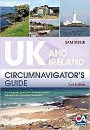
UK and Ireland Circumnavigator's Guide

€32.50*


Product number: 22446

Description

UK and Ireland Circumnavigators Guide

A circumnavigation of the UK and Ireland

A circumnavigation of the UK and Ireland is the perfect challenge for leisure sailors looking for an extended cruise that wont take them too far from family and responsibilities. No extended time off work or language skills are required if something goes wrong - and the coast is beautiful!

This cruising guide is a practical guide with advice on planning and preparation:

  • when to leave
  • whether to sail clockwise or anti-clockwise
  • what charts will be needed
  • how much it will cost
  • possible routes (via canals or "the long way")
  • what equipment will be needed
  • likely pitfalls along the way
  • what types of ongoing maintenance might be required.

The second edition includes the TopTen Most Beautiful Places from secluded coves and beautiful rivers to historic sites and anchorages.

Author: Sam Steele
Format: Hardcover / gebunden
Language: Englisch
Area preview

With the help of our area preview, you can get an impression of which geographical region the product deals with or which areas a nautical chart covers.

Other customers bought also

Other customers bought also

Gebietsvorschau für NV Charts England UK3 - The Solent öffnen
NV Charts England UK3 - The Solent
The NV Charts England UK3 Atlas takes you to the strait between Southampton and the Isle of Wight. Our charts are based on official data from the United Kingdom Hydrographic Office (UKHO) and inc

€64.99*
Gebietsvorschau für NV Charts England UK4 - Selsey Bill to London öffnen
NV Charts England UK4 - Selsey Bill to London
The NV Charts England UK4 takes you past the historic North Foreland into the centre of London - or further west along the coast and towns such as Eastbourne and Brighton. Our charts are bas

€64.99*

Reviews

0 of 0 reviews

Leave a review!

Share your experiences with other customers.


Gebietsvorschau für East Coast Rivers Cruising Companion öffnen
East Coast Rivers Cruising Companion
East Coast Rivers covers the rivers creeks shoals and river sections of the Thames Estuary and surrounding rivers stretching from Lowestoft to Ramsgate.Since 1956 when Jack Coote Jans father published

€49.90*
Gebietsvorschau für CCC Orkney and Shetland Islands including North & Northeast Scotland öffnen
CCC Orkney and Shetland Islands including North & Northeast Scotland
A cruising guide to the Orkney and Shetland Islands which includes Fair Isle. This cruising guide also covers the "jumping off ports" on the south side of the Pentland Firth and the Scottish main

€48.50*
Gebietsvorschau für CCC Kintyre to Ardnamurchan öffnen
CCC Kintyre to Ardnamurchan
CCC Sailing Directions - Kintyre to Ardnamurchan Das von diesem Führer abgedeckte Gebiet erstreckt sich vom Mull of Kintyre bis zur Halbinsel Ardamurchan und umfasst einige der schönsten Segelgeb

€48.50*
Gebietsvorschau für Gezeitenstromatlas NP251 North Sea, Southern Part öffnen
Gezeitenstromatlas NP251 North Sea, Southern Part
Tidal streams diagrams include detailed tidal stream direction and strength information. They show at a glance the direction and rate of tidal streams display neap and spring tidal rates in tenths of

€33.90*
Gebietsvorschau für East & North Coast of Ireland öffnen
East & North Coast of Ireland
A sailing guide to the north-east coast of IrelandFrom Kilmore Quay and Carnsore Point north via Malin Head to Bloody Foreland. This 13th fully revised edition of the East & North Coasts of Ireland Sa

€48.50*
Gebietsvorschau für Isles of Scilly öffnen
Isles of Scilly
The Isles of Scilly Cruising Guide The new edition of this comprehensive guide to the Isles of Scilly has been completely revised and updated. Background information on the islands their history and f

€38.20*
Gebietsvorschau für Gezeitenstromatlas NP250 The English Channel öffnen
Gezeitenstromatlas NP250 The English Channel
BA NP250 Tidal Stream Atlas: The English ChannelTidal streams diagrams include detailed tidal stream direction and strength information. They show at a glance the direction and rate of tidal streams d

€33.90*
Gebietsvorschau für Irish Sea Pilot öffnen
Irish Sea Pilot
A Territorial Guide to the Irish Sea: Wales North Wales South England Ireland North Ireland South and Isle of ManTheIrish Sea is a vast almost landlocked sea. Around its shores and islands are no fewe

€43.00*
CCC Firth of Clyde
Firth of Clyde covers everything from the busy waters of the Firth of Clyde and River Clyde to the more remote areas of the wider estuary and connected lochs, including the protected and beautiful Kyl

€48.50*
Gebietsvorschau für Bloc Marine : Atlantique öffnen
Bloc Marine : Atlantique
The Bloc Marine : AtlantiqueFor accurate information on port areas safety at sea and legal requirements in recreational boating the Bloc Marine Atlantique is a first-class travel companion. It include

€36.00*
Gebietsvorschau für Crossing the Thames Estuary öffnen
Crossing the Thames Estuary
Crossing the Thames Estuary60 routes covering most passages across the Thames Estuary.The problem with planning passage across the Thames Estuary is that each route consists of a number of different s

€38.20*
Gebietsvorschau für Secret Anchorages of Brittany öffnen
Secret Anchorages of Brittany
A detailed cruising guide to Brittany in FranceThe cruising guide "Secret Anchorages of Brittany" is suitable for all water sports enthusiasts planning a trip to Brittany. It covers the entire region

€38.80*